Department of Health Services-Central Province
 With the implementation of Provincial Council Act in 1989, the centrally governed health services were devolved, resulting in the Ministry of Health at the national level and separate Ministries of Health in the nine provinces.
In the Central Province, the Department of Provincial Health Services is under the Ministry of Health, Indigenous Medicine, Social Welfare, Probation & Child care Services. There is a Minister and a Secretary to the Ministry.
The department is responsible for the management and effective implementation of health services, the development of policies and guidelines and the management of human resources within the Province.
The Provincial Director is the head of the Provincial Department of Health Services. There are 3 Regional Directors of Health Services(RDHS) for the province with each covering an area geographically similar to the administrative units of district secretariats.

Each RDHS area comprises of several divisional secretary areas in which the responsibility of preventive health care lie within the respective Medical officers of Health (MOH). The provision of curative care occurs through the primary, secondary and tertiary health care institutions scattered through the province. The Medical Superintendents (MS), District Medical Officers or Medical Officers In Charge (MOIC) carry out the latter responsibility through their institutions.
The Central Province of Sri Lanka
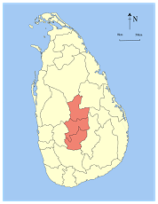 The Central Province is located in the central hills of Sri Lanka and consists of the three Districts: Kandy, Matale, and Nuwara Eliya. The total land area of the Province is 5,674 square kilometers, which is approximately 8.6% of the total land area of Sri Lanka. The Province lies on 6.6°- 7.7° Northern latitude and between 80.5°-80.9° Eastern longitudes. The elevation in the Province ranges from approximately 100 meters (about 330 feet) to over 6,000 feet above sea level in the central hills. The Province is bordered by the North Central Province to the North, the Uva Province to the East, the North Western Province to the West, and the Sabaragamuwa Province to the South and West. The Mahaweli river, Uma Oya, the mountain range of Adam's Peak, Kirigalpottha, Thotapala, Dolosbage, and Galagedera are some of the key geographical features defining its borders.
The mean temperature ranges from 16°C to 28°C in the Province, with lower temperatures recorded in the hills of the Nuwara Eliya District. The province is well known for its production of Ceylon tea. The land use in the province involves various cultivations, including tea, paddy, coconut, and rubber.
For the purpose of administration, the Central Province has 33 to 36 Divisional Secretary areas across the three Districts. These are further divided into approximately 2,224 Grama Niladari areas, and thousands of villages and local government bodies comprising municipal councils, urban councils, and Pradeshiya Sabhas.
The Provincial administration is vested in the Central Provincial Council, which is composed of elected representatives of the people and headed by a Governor appointed by His Excellency the President.
According to the 2024 Census data, the total population of the Central Province was approximately 2,714,045. The population density was around 478.3 persons per square kilometer. According to the 2012 census, the population distribution by sector was roughly 70.0% rural, 20.2% estate, and 9.8% urban, though these proportions may have shifted with recent population changes. The average annual growth rate of the population for the intercensal period of 2012-2024 was about 0.5%. The majority ethnic group is Sinhalese (around 66.0%), followed by Tamils (both Indian and Sri Lankan), and Moors.


